
Beyond the Bell Tower
Where the line has been drawn

The Turret Journal — Essay V
Every map draws a line. In Port Townsend, that line has stopped short of the upper end of Tyler Street — a continuous Victorian streetscape that lies beyond the routes and materials that define the city's architectural narrative.

Port Townsend was founded on April 24, 1851. This year, the city marks its one hundred seventy-fifth anniversary. The date also coincides with the opening of the 2026 Victorian Heritage Festival, a coincidence that does not occur every year and that sharpens the focus of both.
Each spring, the city turns to its past and directs attention to what remains. Walking tours, open houses, and events of all kinds gather into a season with the same gesture: pointing. Look here. Look at what has been preserved.
But the act of pointing is also an act of selection.
Every map draws a line. Every tour indicates where to turn and where to turn back. And in Port Townsend, even with its celebrated reputation as a haven for Victorian architecture, that line is often drawn more narrowly than the city itself.
Our family first visited Port Townsend in 2003, and we returned periodically over the years for weekend getaways from Seattle. We walked the city as it was presented — following maps, tracing routes, stopping where others stopped, admiring what we were led to admire. We assumed the frame was complete.
We had been to town a few times before we even ascended the bluff to explore Uptown — and when we did, our sense of historic Uptown worth looking at still wasn’t complete and essentially ended at Lawrence.
Then the line broke.
In January of 2022, we began visiting with a different purpose. We were considering a move, looking for a property that could operate as a bed and breakfast, and had two properties in mind — one of some renown, the other entirely off the usual routes. We returned more than five times to view them, neither ultimately suiting us. But what happened across these visits was that the fullness of Uptown started to become more legible. We had always driven in and out of the city through downtown, via Sims Way. But one day in late February, we left town by a different route, turning onto Tyler Street and continuing toward F.
Joseph drove. I watched the houses.
And as Joseph slowed to take the curve onto F, I saw a large Queen Anne Victorian appear as if out of nowhere — the chestnut color, the porch, the height, and above all the turret. This house sat outside what I had come to understand as the extent of the city’s historic fabric.
It was the house at 1028 Tyler.
I remember reacting aloud — surprise, then a question: How much else had we not seen?
A man I now know to be the former owner, Marshall Raney, was working in the yard. There was no for-sale sign. We drove on. I didn’t have more than a few seconds to take it all in.
In mid-March, during one of my nightly real estate searches, I happened to observe the moment it appeared on the market. We called our realtor, who learned there were other buyers already in line, traveling up from California within the week. I cast my search wider — Oregon coast, Upstate New York, east coast. A week later, the owner contacted our realtor. The California buyers fell through. Were we still interested?
We were there the next day. Within a week we had an accepted offer. On May 25, we moved in.
Only after we had moved in and begun re-establishing the house as a bed and breakfast did we look more carefully at how it, and the street it sits on, were positioned within the city’s official narratives. Or rather, how they were not.
The Chamber of Commerce map did not extend this far. The Wikipedia entry about Port Townsend’s historic district describes it as “roughly bounded on the northwest by Blaine Street” — one block shy of the corner of Tyler and F, cutting short just steps from two of the twenty-two houses classified as pivotal in the city’s Historic Residence Inventory. The materials produced through the Port Townsend Main Street program, which has stepped up to fill the tourism void left by the Chamber’s closure in 2024, focus understandably on the downtown commercial district. And when we had contacted the Port Townsend Heritage Association in 2023 to inquire about including the Albert C. Adams House at 1028 Tyler on their summer Uptown walking tours, we were told the distance from the tour’s starting point at the post office made it impractical: the guide could manage it perhaps once or twice a season if the group seemed up for a longer walk.
Each of these decisions has a practical basis.
Taken together, they produce a consistent result. The architectural story of Port Townsend, as commonly presented, gathers at the bluff and diminishes well before it reaches the interior of the neighborhood.
That is not how the city was built.
Tyler Street, at its full length, is less than half a mile.
Maps make arguments.
Every boundary is a judgment. Every omission defines what becomes visible. The current conceptual mapping of Uptown for visitors presents something real. It also leaves out a substantial portion of the same built environment.
Port Townsend’s new tourism brand is “Off the Path, On the Edge.” The tagline earns its keep — the city sits at the far end of a peninsula at the far end of a county, with water on three sides, the Strait of Juan de Fuca opening to the north, and the Olympics rising to the west. You don’t pass through Port Townsend on your way somewhere else. You come here because you meant to.
What we would add, from the far end of Tyler Street, is that the edge extends further than current conceptual mapping suggests.
Tyler is not a peripheral street. It runs from Port Townsend Bay’s waterfront downtown, to the base of the bluff, where the 1890 Bell Tower — the last remaining wooden fire bell tower in the United States — still marks the skyline above downtown and is a visible reminder of what was “central” from the perspective of safety. From the Bell Tower on top of the bluff, Tyler continues through the Uptown commercial district, through the residential interior of the neighborhood, and on toward Morgan Hill. It is connective tissue, a main artery that bends just before its final northwest extension, into F Street en route to Fort Worden and the locals’ way out of town.
From April through December each year Jefferson County’s Saturday farmers market occupies the segment of Tyler from Clay to Lawrence. At the intersection of Tyler and Lawrence, that continuity has a fixed address. Aldrich’s Market has stood here, in one form or another, since the 1880s — the oldest continuously operating grocery store in Washington State. This intersection is where downtown’s gravitational pull releases and the residential city begins in earnest. It is also, not coincidentally, where the walking tours and tourist maps often find their limit.
But the segment of Tyler Street that extends past the Lawrence threshold has retained an extraordinary degree of architectural continuity.
From the early houses of the 1860s and 1870s through the concentrated building of the late 1880s and into the first years of the twentieth century, Tyler holds one of the most intact sequences of Victorian-era residential structures in Port Townsend — and we believe, having walked it in every season and studied its record in some depth, possibly the most intact of any residential street in the city. What remains is not only individual buildings but the relationships between them: spacing, rhythm, orientation, scale.
A fabric, not a collection.
From Lawrence west through Blaine and past the houses that gather around Tyler and F, the south side of the street is composed almost entirely of structures built before 1900 — a continuity of historic homes whose architectural landscape has looked largely the same for more than a century. The north side isn’t far behind. In all, Tyler Street is lined with 31 historic structures. We know of no other residential street in the city that can make the same claim with equivalent confidence, though neighboring Taylor Street, which runs parallel to Tyler, is close at 28.
Earlier in its history, the section of Tyler northwest of Lawrence was known by another name thanks to Captain Henry Morgan, who built multiple houses along this stretch in the late 1880s and he lined it with maple trees. The name that resulted — Maple Avenue, Maple Street, both names sometimes applied simultaneously, the record not being especially consistent — described what you would have seen standing on the block and looking up toward Morgan Hill. Most of the maples are gone, replaced by other plantings over other decades. The name Maple persisted formally at least through 1902 and informally, from what we’ve found, until at least 1938. Over time, the name Tyler prevailed.
Captain Morgan’s own house stands at 857 Tyler, built in 1866 and expanded with evident care over the following decades — a side gable and wraparound porch added before 1911, changes made in sympathy with the original structure rather than against it. Morgan arrived in Port Townsend and proceeded to shape the physical city in ways still visible from almost any vantage point in Uptown. Beyond the houses on Tyler, he acquired what would become Morgan Hill, served in the Territorial Legislature, acted as federal Inspector of Hulls, bought and sold Protection Island twice, drilled for coal on Marrowstone Island, and started a teachers’ college — sited on Morgan Hill — that, like the maples he planted along this street, didn’t survive. His house did, and its front yard is a botanical richness that shares its abundance with Aldrich’s customers during the growing months.

At 820 and 828 Tyler, there is a pair of matching cottages built in 1888 as rental properties by the principals of Waterman & Katz, a leading Port Townsend business of the era. The firm was established by Sigmund Waterman and Solomon Katz, who had come from Germany; after Solomon’s death in 1879, his brothers William and Israel took over his stake. By 1888, when the cottages were completed and recorded in the county tax ledger under William Katz’s name, both William and Sigmund Waterman had died — leaving Israel Katz and Sarah Waterman as the surviving principals. Israel Katz became sole owner of the properties by 1891. He would later build his own house further up the street.

At 829 Tyler stands another of several houses Morgan built along what was once known as Captains Row. At 841 Tyler, the Hinds family house: John F. Hinds, grocer, whose shop stood at the southwest corner of Tyler and Lawrence, and whose wife A.M. Hinds was recorded as the owner of two improved lots on Maple Street in the county tax ledgers of 1887 and 1888.
The Francis Pettygrove duplex at 738–740 Tyler, built between 1888 and 1890, carries a name with unusual reach: Frank Pettygrove Jr.’s father, Francis W. Pettygrove Sr., was one of the founders of Portland, Oregon, who in 1845 won the coin toss that gave that city its name rather than the alternative — Boston. The son built and lived in the southern half of this duplex on Maple Street; the northern half was occupied by Dr. Charles M. Baldwin and his boarders.

At 809 Tyler, the William Harned house, likely built in 1875, possibly also by Morgan. William Harned worked as a Deputy Collector of Customs and later as a real estate broker. His second wife, Mollie Brooks, was an artist and student of Harriet Foster Beecher — a noted Puget Sound painter, and by marriage a niece of Harriet Beecher Stowe.

At 933 Tyler, the same Israel Katz who had inherited the twin cottages at 820 and 828 built a house in 1889 for his wife Adele. He became a prominent local businessman and served as mayor from 1915 to 1916. One morning in 1917, he left behind the personal effects anyone would normally take with them and simply disappeared. He was never found.

Across from our house, at 1023 Tyler, the Howard Smith house, built between 1885 and 1888, looks from the street essentially as it did in an 1889 photograph — one of the more direct comparisons available on the street.

At the the place where Uptown begins — the intersection of Tyler and F — Tyler’s upper block also begins in earnest.
The James Stockand House — which technically fronts F Street but has its largest surface fronting Tyler — dates to 1889. James W. Stockand was twenty-six years old when he built it, with the help of his brother-in-law Thomas Drummond, a Port Townsend contractor. Drummond’s own family houses stand further up the street, at 1221 and 1229 Tyler — built on land Peter Stockand sold in 1884 to his daughter Annie, who was Drummond’s wife. So Thomas Drummond was both James Stockand’s in-law and his builder; the street knits its families together in ways the property records only partially capture. The Stockand house and its carriage house were finished by 1890; it is the only seven-gabled house in Port Townsend. As with many historic homes in the city, rooms were rented to Fort Worden soldiers during the Second World War, and it came close to ruin before a restoration in the late 1970s earned it the local Mary Johnson Award. It has been beautifully maintained and further restored since. It is extraordinary.

In 1890, the larger of the two Drummond houses, at 1221 Tyler, was occupied by Richard A. Ballinger. At the time, Ballinger was practicing law in Port Townsend and serving as a superior court judge for Jefferson County. He would go on to become mayor of Seattle and to be appointed by President Taft as Secretary of the Interior — his tenure defined by the Ballinger-Pinchot conservation controversy that helped fracture the Republican Party in 1912. In 1890 he was a young man in a rented house on Maple Street.

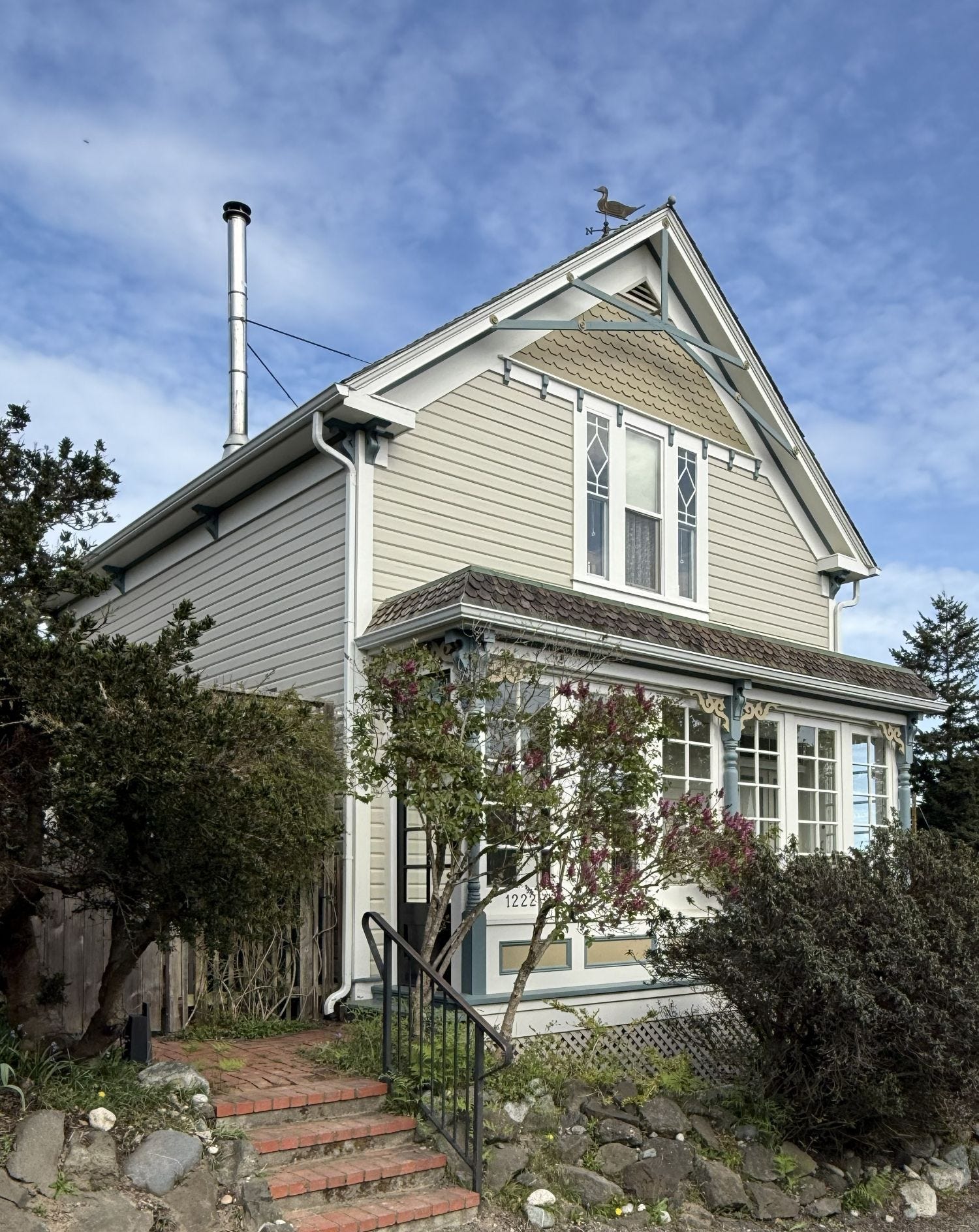
And our house — whose history I’ve only just started sharing — at 1028 Tyler: the Albert C. Adams House, built in 1889 in the Queen Anne style with elements of the Italianate Villa and the Stick. Fifteen rooms. The house looks as it has looked for more than a hundred and thirty years.
Nothing on its face announces that anything has changed.
Many of these buildings are documented individually. They are never presented as a sequence.
Our recognition of that sequence and its merit did not arrive all at once. It emerged over time, and on foot.
During our first year in the house, Joseph and I would take long after-dinner walks together through the neighborhood. Unlike anywhere else we’ve lived, where the scenery eventually becomes routine, this neighborhood remains endlessly interesting: new things to notice, new ways of looking as the seasons change. An idea started to take shape, and once Joseph set his sights on the project formally, for more than a year he walked the city twice daily with our dog, taking different routes each time — sometimes gone a long time, covering ground the official tours didn’t reach — photographing houses that looked old, noting addresses, then researching them at home against maps, directories, tax records, and archival materials. What began as attention became method. Patterns emerged through repetition rather than selection.
The result is the Explore Victorian Port Townsend interactive map, a record assembled from the ground up rather than from established routes. The map now documents more than 350 surviving Victorian-era homes and buildings across Port Townsend. It is a map of relationships, not destinations — an attempt to render visible the architectural continuity that still defines the city but is only partially conveyed by existing representations. Where possible, it presents historic photographs for contemplation alongside walkers’ present-day views, allowing direct comparison of how the lived needs of residents have changed the visible structures.
A visitor exploring Uptown from the Bell Tower — up Tyler through the commercial district, past Aldrich’s, all the way past the bend at F to Taft, then taking Taft to Taylor and back along Taylor to Jefferson — will have seen, along these two principal streets and the cross streets visible from them, a comprehensive cross-section of Victorian Port Townsend in the most concentrated area of the city. From Tyler you can glimpse historic churches and even catch a view of other pivotal houses such as the Starrett and Peter Mutty houses. For those willing to take on a bit of incline, the loop of Blaine and Garfield adds another condensed layer. No tour shows everything. But this one gives you a sense of the extent of what’s here — beyond downtown and the bluff, beyond the courthouse and the post office and the three houses on the National Historic Register — all of which visitors can find on their own.
Here at 1028 Tyler Street — the Albert C. Adams House — there is no signage on the exterior of identifying it as an inn: The Adams Pragge House. The residential character of the block matters to us as neighbors. That decision avoids altering the immediate character of the block and aligns with the approach taken in our Explore Victorian Port Townsend map. The map makes no argument for any particular route through town.
We are not presenting the city’s history as an object apart from the city. We are participating in its existing continuity — as stewards of the Albert C. Adams House, of Tyler street, and of practical access to the architectural record Port Townsend holds in such uncommon concentration.
This year, as Port Townsend marks its one hundred seventy-fifth anniversary and the Victorian Heritage Festival opens on April 24, visitors will fill the city and will walk along the established routes.
Those routes stop short.
Beyond the Bell Tower and well past Lawrence, Tyler continues. So does the record.
The Explore Victorian Port Townsend interactive map, a public heritage project of the Adams Pragge House, is available at:
https://adamspraggehouse.com/explore-victorian-port-townsend/
Zhenya Lavy writes The Turret Journal from within the Adams Pragge House, an 1889 Victorian in Port Townsend, Washington, where she and her husband serve as its stewards.
The Adams Pragge House is a three-suite bed and breakfast in Port Townsend, Washington. Learn more at adamspraggehouse.com.
→ https://adamspraggehouse.com
Related Essays from The Turret Journal: